South DakotaDepartment of Transportation
Transportation
Aviation
About Office of Aeronautics Services
Office of Aeronautics Services
Airports Conference
Aerospace Education
Airport Information
Links
Aviation Systems Plan
Bridges
Office of Bridge Design
Design & Plans
Historical Bridges
Inventory & Inspection
Posted Structures
Reference Information
SD Bridge Photos
Doing Business
Certification & Accreditation
About Certification & Accreditation
SDDOT Accreditation Certification List
Approved Products
Manuals & Documents
Welding Certifications
Training
Contractors
Bid Letting Information
Concrete Pipe Release
Contractors/Suppliers
Prequalified Contractors
CMS Web Reports
Disadvantaged Business Enterprise (DBE)
Fuel Price Index
Labor Compliance
Materials
Preconstruction Meetings
Price Adjustment Guidelines
Standard Specifications
Subcontract Requirements
Forms & Documents
Webinars
Alternative Contracting
Engineering/Design Services
Consultant Services
Downloadable Files
Manuals
News & Updates
Right of Way / Relocation Assistance
Standard Bid Items
Standard Plates
Surveyors
Utility Coordination
Environmental
About Environmental
Agreements
Endangered Species
Environmental Assessments
Forms
Stormwater
Wetland Mitigation
Local Governments
About Local Governments
Bridge Improvement Grants
City/County Fund Balances
Emergency Relief (ER)
Federal Bridge Program
Forms & Documents
Secure Accounts Billing
Transportation Economic Development Grants
Urban Systems
Rural Access Infrastructure Fund Program
Traffic Incident Management
Training
Projects & Studies
Planning
Carbon Reduction Strategy
Freight Plan
Long Range Plan
Metropolitan Planning Organization
Non-state Public Road Inventory
Pavement Condition Monitoring
Pavement Management
South Dakota EV Fast Charging Plan
Statewide Transportation Improvement Program – STIP
Transportation Asset Management Plan (TAMP)
Inside SDDOT
Forms & Publications
Brochures
Forms
Manuals
Maps
Newsletters
Reports
SDDOT Engagement Opportunities
Join One of Our Contact Lists
Press Releases
Media Kits
News Stories
Branding and Identity Guidelines
Learn More about the SDDOT Logo
SDDOT Blog
Highway Classification
Highway Classification
County Highway Systems
Project Development is the official record keeper of the primary "County Highway System" as specified in SDCL 31-12-2. Roads can be added or deleted from this designated system, but must follow these Procedures.
Roads are added or removed at the local county level. The respective county commissioners make these decisions based on their knowledge and public input. They pass a resolution specifying the modification and forward to SDDOT for processing. Here the resolution is reviewed to insure the necessary steps have been taken and presented to the secretary of the South Dakota Department of Transportation.
There is also a "County Secondary Highway" designation. This is defined as the next lower level of roads in counties with no organized townships. This would be known as township roads in counties with organized townships. However, this law does not apply to this designation. If the county does add or remove roads from the "County Secondary Highway," these modifications should be reported to Greg Pollreisz in Transportation Inventory Management.
County Highway System Maps By County are available on the Interactive Road System Maps website.
Federal Aid
Planning and Programs is responsible for working with local governments to depict which roadways are eligible for receiving federal-aid for construction and improvements.
All public roads functionally classified at least as a rural major or urban minor collector or higher classification are eligible for Federal assistance provided by ISTEA and continued through FAST Act. These roads are referred to as "Federal-aid Highways".
Prior to the Intermodal Surface Transportation Efficiency Act (ISTEA) of 1991, the Federal-aid Highway Program was directed primarily toward the construction and improvement of four Federal-aid systems: the Interstate (FAI), Primary (FAP), Urban (FAU) and Secondary (FAS) systems. The ISTEA restructured the Federal-aid system and repealed the FAI, FAP, FAU, and FAS system. Instead of four Federal-aid systems, there are now two federal-aid systems: The National Highway System (NHS) and the Surface Transportation Program (STP). The Interstate system, is a component of the NHS.
For areas of less than 5,000 population, the Surface Transportation Program permits up to 15 percent of the amount reserved for rural areas to be spent on rural minor collectors, at the State of South Dakota's discretion. South Dakota Department of Transportation also distributes a portion of the STP funding to urbanized areas above the population of 5000. The Office of Administration is responsible for the distribution to the local government entities.
Flood damage to non-federal-aid roads may be eligible for FEMA funding.
Functional Classification
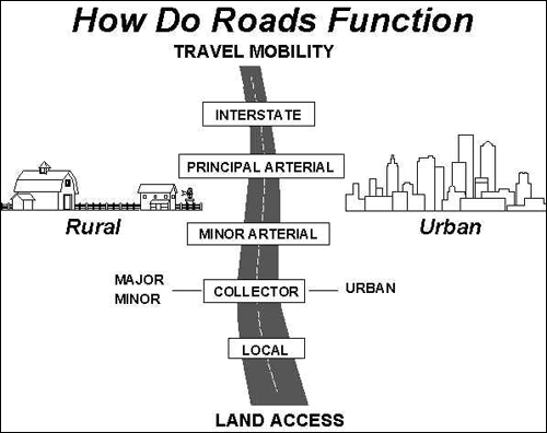
Project Development is responsible for coordinating the functional classification for all roads in South Dakota. Functional classification refers to the type of service each particular road provides the traveling public. Functional Classification designations include:

Planning and Programs coordinates with city, county, and federal government agencies as well as other local and tribal entities to determine mutually agreeable designations for these roads. These recommended designations are then forwarded to FHWA for final approval.
In addition to describing the type of service, the functional classification designation is also used to determine federal funding eligibility. All roads except those classified as Minor Collector and Local are eligible for participation in federal funding. There are, however, a limited number of roads that are also eligible for federal funding regardless of the functional classification designation. These are roads that were eligible under the previously designated "federal aid system". If you want to determine this possible eligibility for any roads functionally classified as minor collector or local, email your request to the person indicated above or call during normal working hours.
Highway Functional Classification Manual
State Highway Functional Classification Map
| Classification | Type of Service |
| Principal Arterial - Interstate | Urban and Rural |
| Principal Arterial - Expressways | Urban and Rural |
| Principal Arterial - Other | Urban and Rural |
| Minor Arterial | Urban and Rural |
| Major Collector | Rural |
| Collector | Urban |
| Minor Collector | Rural |
| Local | Urban And Rural |

Planning and Programs coordinates with city, county, and federal government agencies as well as other local and tribal entities to determine mutually agreeable designations for these roads. These recommended designations are then forwarded to FHWA for final approval.
In addition to describing the type of service, the functional classification designation is also used to determine federal funding eligibility. All roads except those classified as Minor Collector and Local are eligible for participation in federal funding. There are, however, a limited number of roads that are also eligible for federal funding regardless of the functional classification designation. These are roads that were eligible under the previously designated "federal aid system". If you want to determine this possible eligibility for any roads functionally classified as minor collector or local, email your request to the person indicated above or call during normal working hours.
Highway Functional Classification Manual
State Highway Functional Classification Map
Contacts
Aviation
About Office of Aeronautics Services
Office of Aeronautics Services
Airports Conference
Aerospace Education
Airport Information
Links
Aviation Systems Plan
Bridges
Office of Bridge Design
Design & Plans
Historical Bridges
Inventory & Inspection
Posted Structures
Reference Information
SD Bridge Photos
Highways
About Highways
Access Management
Data Analysis
Geotechnical
Highway Classification
Highway Safety
Traffic Data
Public Transit
General Information / Notices
Procurement
Provider Network
Rural Transit
Specialized Transit
Urban Transit Planning Program Units
Forms, Policies, and Publications
Railroads
© 2026 State of South Dakota. All Rights Reserved.
South Dakota Department of Transportation
Becker-Hansen Building
700 E. Broadway Ave.
Pierre, SD 57501
Becker-Hansen Building
700 E. Broadway Ave.
Pierre, SD 57501
Powered by:
Modern Logic
Modern Logic
Region & Area Offices
Travelers
© 2026 State of South Dakota. All Rights Reserved.
South Dakota Department of Transportation
Becker-Hansen Building
700 E. Broadway Ave.
Pierre, SD 57501
Becker-Hansen Building
700 E. Broadway Ave.
Pierre, SD 57501
Powered by:
Modern Logic
Modern Logic


